
The Scrap Yard Next Door: Mapping New Jersey's Metal Recyclers
Why scrap yards?
Scrap metal recycling is useful work. It keeps metal out of landfills and supplies steel mills. But scrap yards can be hard neighbors: shredders and cranes generate noise and dust, heavy trucks come and go all day, metal piles can catch fire, and rainwater running off a yard can carry oils and metals. New Jersey’s Environmental Justice Law names scrap metal facilities as one of the eight facility types that need extra review in overburdened communities, and it lists scrap yards as an environmental stressor in their own right (New Jersey Legislature, 2020).
Scrap recyclers have also been central to the legal fight over the law. Their trade association’s New Jersey chapter was one of the groups that challenged NJDEP’s rules in court (my post on the appeals court ruling). Where are New Jersey’s scrap yards, and who lives near them?
Data
NJDEP maintains a statewide list of 440 scrap metal facilities with locations (NJDEP, 2025). I combined it with population counts for about 113,000 populated census blocks and the overburdened community (OBC) map in effect in August 2026.
Findings
Concentrated in overburdened communities
62% of scrap metal facilities are located inside OBC block groups, even though OBCs cover only 23% of New Jersey’s land. The counties with the most are Essex (48), Middlesex (44), Camden (39), Hudson (29), Bergen (28), and Gloucester, Passaic, and Monmouth (27 each).
A kernel density estimate, which turns individual points into a smooth surface showing where facilities cluster, highlights hot spots in the Newark–Elizabeth–Jersey City corridor, the Camden waterfront, and central New Jersey (Figure 1).
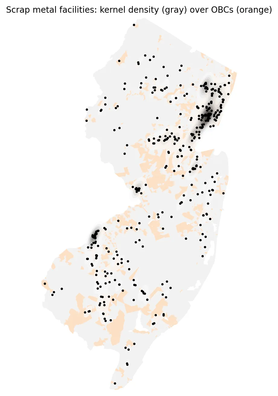 Figure 1. Scrap metal facilities cluster in northeastern New Jersey and Camden, where many overburdened communities are located.
Distance to the nearest scrap yard
For each census block, I measured the distance to the nearest scrap metal facility:
| Overburdened community residents | Other residents | |
|---|---|---|
| Median distance to nearest scrap yard | 1.15 miles | 2.47 miles |
| Living within ½ mile | 16.5% | 4.0% |
| Living within 1 mile | 43.6% | 13.4% |
Residents of overburdened communities are about four times as likely to live within half a mile of a scrap yard, and about three times as likely to live within a mile.
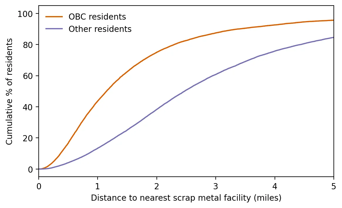 Figure 2. At every distance, a larger share of overburdened community residents live close to a scrap yard.
Figure 2 shows the full picture as a cumulative distribution: at every distance, a larger share of OBC residents live that close. A Kolmogorov–Smirnov test, which compares two whole distributions rather than just their averages, confirms the difference is far too large to be due to chance (D = 0.38).
Why this matters
Scrap yards cluster in older industrial areas near ports, rail lines, and highways, the same places where many overburdened communities live. Because the EJ Law treats scrap yards both as regulated facilities and as stressors, a neighborhood with several yards scores higher on cumulative burden, which can make it harder for a new yard to get a permit there. But most existing yards are already operating. Their impacts are managed through ordinary permits, local zoning, and the law’s conditions on expansions and renewals.
Limitations
- Locations are points. Large yards occupy sizable parcels, and the point may be an office address.
- Not all yards are equal. A small collection site and a large shredding operation count the same.
- Proximity is not exposure. Distance doesn’t measure noise, dust, or runoff directly.
- List timing. NJDEP’s list was last updated in February 2025.
Code project (Level 5): density and distance
Goal: Map where scrap metal facilities cluster, and compare how close OBC and other residents live to them.
Data: NJDEP Scrap Metal Facilities in New Jersey; 2020 Census blocks; NJDEP OBC list in effect on the cutoff date.
Method:
- Spatially join facilities to block groups to see what share lie in OBCs.
- Build a KD-tree (a fast nearest-neighbor search structure) of facility locations and find the nearest facility to each block.
- Compute population-weighted medians and the share living within ½ and 1 mile.
- Draw cumulative distribution curves and run a Kolmogorov–Smirnov test on population-weighted samples.
- Estimate a 2-D kernel density surface with
scipy.stats.gaussian_kde.
tree = cKDTree(np.c_[scrap.x, scrap.y])
dist_ft, _ = tree.query(np.c_[blocks.x, blocks.y])      # nearest facility for 113,000 blocks in a fraction of a second
ks = ks_2samp(obc_sample, other_sample)
New skills: spatial indexing for fast nearest-neighbor searches, density estimation, and comparing whole distributions.
Data and methods
Data sources
- NJDEP *Scrap Metal Facilities in New Jersey*; 2020 Census blocks; NJDEP OBC list in effect on the cutoff date.
The analysis was done in Python with public data. The full code, its data, and every figure it produces are in the code project below.
References
- New Jersey Department of Environmental Protection. (2025). Scrap metal facilities in New Jersey [Data set]. https://www.arcgis.com/home/item.html?id=10e8a968d2214ac7977b232c4ace6435
- New Jersey Department of Environmental Protection. (2026). Environmental Justice (EJ) Law Combined Stressor Summary (Current) [Data set]. https://www.arcgis.com/home/item.html?id=8f1eeb5074d147af8ab3e5e5a4f72d2b
- New Jersey Legislature. (2020). P.L.2020, c.92. https://pub.njleg.gov/bills/2020/PL20/92_.PDF
- U.S. Census Bureau. (2021). TIGER/Line shapefiles: 2020 tabulation blocks, New Jersey [Data set]. https://www2.census.gov/geo/tiger/TIGER2020/TABBLOCK20/